Lichens on basalt

Liking Lichens

Liking Lichens

Lichens on basaltLichens #59874 Purchase

One of my favorite quirky subjects I love to photograph are lichens. Lichens grow just about everywhere but unfortunately are unappreciated by most people. They are some of the oldest organisms on land, going back perhaps 600 million years. They live in some of the most extreme conditions and are an important food source for animals such as caribou. For humans they are a natural source of antibiotics and pigments. Lichens are also an indicator of clean air as they will not grow in the presence of  pollutants.

During my recent visit to Cottonwood State Park in Oregon I saw some outstanding lichen colonies. A large outcropping of columnar basalt which remains in shade harbored a beautiful display in many striking colors. Juxtaposed against the interesting patterns and cracks of crystallized basalt, the lichens made a wonderful abstract study.

Admittedly this kind of subject matter isn’t appealing to everyone, but I had a great time picking out interesting compositions.

Lichens on basaltBasalt and Lichens #59895  Purchase

Lichens on basaltLichens #59869  Purchase

Lichens on basaltLichens and Basalt #59897  Purchase

Lichens on basaltBasalt and Lichens #59881  Purchase

Liking Lichens
John Day River Oregon

John Day River Oregon

John Day River Oregon

John Day River OregonJohn Day River, Oregon #59904     Purchase

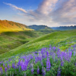
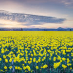
This post will begin a series of recaps from my recent spring photography trip. My first stop was Cottonwood Canyon State Park, along the lower John Day River Oregon. This is Oregon’s newest state park and it was a pleasure to visit. As you can see from the photos the surrounding country is part of the Coloumbia Plateau, with the John Day River cutting canyons through the flood basalt. The nature of this geology helps the river create many scenic winding turns and horseshoe bends.

John Day River OregonJohn Day River, Oregon #59852    Purchase

Visiting this area in early spring offers cool green hillsides sprinkled with a variety of wildflowers. Most notably Balsamroot (Balsamorhiza sagittata) and Desert Parsley (Lomatium laevigatum). Later in the season the hills will turn a golden brown, and the weather will be much hotter. The park was donated by a local ranching family and contains several remnants of its past, such as a picturesque red barn and some farming implements. A small campground is located right along the river where several nice riverside trails begin. If you’re not into natural history or photography the river is supposedly great for fishing and the spring runoff offers excellent rafting.

Red Barn Cottonwood Canyon State Park OregonRed barn Cottonwood Canyon State Park, Oregon #59841    Purchase

Hiker John Day River, Cottonwood canyon State Park, OregonJohn Day River Cottonwood Canyon State Park, Oregon #59797    Purchase

Photography, of course, was the main reason for my visit. The goal was finding some nice views of the river bends. This proved however to be a bit of a challenge as many of the best bends were inaccessible by road or foot. After scouring Google Maps I did manage to find a backroad close to the canyon rim with a nice view. My research showed the best horseshoe bend view is situated about an hour drive south of the park. The weather forecast didn’t look good enough to make the trip worth it though. That one will have to wait until my next trip to the area.

John Day River OregonDesert Parsley, John Day River, Oregon #59858    Purchase

A couple words of warning if you visit this quiet and special area. All unsurfaced roads can be impassable to vehicles after a rain, they turn into a gluey gumbo. Trust me on this, I once almost got stuck and had to wait a couple of days for the road to dry out before I could safely proceed. Rattlesnakes are common, and in spring ticks can be a problem. Also in late spring and summer the temperature can be very hot, with little shade to provide relief.

If you’d like to see more photos from this area you can search John Day River or Cottonwood Canyon State Park on my website. All photos can be licensed for editorial or commercial use or also be purchased as prints. Thanks for viewing and please pass this post along to your friends!

John Day River OregonJohn Day River, Oregon #59912     Purchase

John Day River Oregon

Mount Shasta California

New Images Mount Shasta

New Images Mount Shasta

Mount Shasta CaliforniaMount Shasta #60133    Purchase

I’m still working on the long process of editing all the new images from my recent trip to California and Oregon. However, there are some obvious highlights I’m anxious to share, this photo of Mount Shasta being one of them.

Making this photo was one of those lucky close calls. After driving south all day from Hood River Oregon I noticed some interesting clouds developing as I approached the California state line. Nearing the town of Weed CA it became apparent there was going to be some good light over Mount Shasta. However I was still miles away and not familiar with the area. Taking a clue from my trusty guidebook, Photographing Northern California by Gary Crabbe, I sped down a nearby ranch road and managed to set up my tripod just in time to make several exposures.

I’m pretty happy with the results, but further scouting the next day revealed an even better composition just a mile further down the same road. There was even an exit on I-5 that could have gotten me there faster. Oh well, there’s always a next time.

Imnaha Canyon wildflowers Oregon

Oregon Northern California Spring Photography

Oregon Northern California Spring Photography
 s
Imnaha Canyon wildflowers OregonHells Canyon Recreation Area, Oregon  #45010  Purchase
s

This week I will be leaving for an extended Spring trip to photograph landscape nature and travel imagery throughout Oregon and Northern California. During this excursion I’ll be photographing some new locations and subject matter, along with adding depth to places I’ve previously covered. Check out some of the exciting areas on the itinerary below.

Oregon: Hood River Valley Orchards, Southern Coast, Owyhee River and Canyon, Wallowa Valley Hells Canyon Area.
California: Redwoods National Park, Mount Shasta, Mendocino Coast, Point Reyes, Sonoma Valley Vineyards.
 s
Shore Acres State Park OregonShore Acres State Park, Oregon  #48705  Purchase
Red barn Wallowa Valley OregonWallowa Valley, Oregon  #44829 Purchase
 Redwood forest CaliforniaCalifornia Redwoods  #44497  Purchase

Skagit Valley Daffodils

Skagit Valley Daffodils Snow Geese

Skagit Valley Daffodils Snow Geese

Skagit Valley DaffodilsDaffodils Fields in the Skagit Valley  #50700  Purchase

Skagit Valley Daffodils Snow Geese, two sure signs that spring is here in the Northwest, even if the weather says it isn’t.

If you’re planning on visiting this famous destination in the coming weeks here is the latest report from RoozenGaarde. As you probably expected, blooms are a little behind schedule this year due to the prolonged cold weather.

Snow geese Skagit Valley A large flock of Snow Geese taking flight in the Skagit Valley  #15870  Purchase

Clayton Beach sunset Larrabee State Park

Samish Bay Bellingham Bay

Samish Bay Bellingham Bay

Clayton Beach sunset Larrabee State ParkClayton Beach Sunset, Larrabee State Park, Washington  #59666  Purchase

Once again its time to post some new photos from my favorite winter doldrum photo haunts, Larrabee State Park and Bellingham Bay. These locations are only a few miles from my home, so when I can’t get out on some winter ski trips I head to the local beaches for some fresh air and inspiration. These photos were made within a two day period when there was a lively mixture of sunny and stormy weather, a time during which you can usually get a wide variety of lighting conditions. To read more about Larrabee State Park check out this post from last year.

Clayton Beach sunset Larrabee State ParkClayton Beach Sunset, Larrabee State Park, Washington  #59681  Purchase

Bellingham Bay WashingtonStorm clouds over Bellingham Bay, Washington  #59689   Purchase

Cormorant, Bellingham Bay WashingtonCormorant, Bellingham Bay, Washington  #59699  Purchase
Bellingham Bay WashingtonBellingham Bay, Washington  #59692  Purchase

Nooksack Tower North Cascades

North Cascades Washington

North Cascades Washington

As I’ve mentioned in many posts, North Cascades Washington is one of my favorite places to get out and enjoy a rugged wilderness setting, and since I live in Bellingham Washington it is also practically in my backyard. Over the past several weeks I’ve made a few leisurely hikes and backpacks to some of my regular spots. Below are some photos from these trips that help illustrate the wild and rugged nature of this magnificent range. Enjoy!

Nooksack Tower is, in my opinion, one of the coolest and most dramatic looking peaks in the North Cascades. Topping out at a modest 8268′ / 2520m it is an outlier of the Mount Shuksan massif. Nooksack Tower has also been famously  labeled by legendary climber Fred Beckey as one of the most difficult climb in the North Cascades, equaled possibly only by nearby Slesse Mountain (the “Fang”) in British Columbia. In this view from above Hannegan Pass a layer of fresh spring snow adds to the formidable appearance of the tower.

Nooksack Tower North CascadesNooksack Tower #58069  Purchase

Ruth Creek Valley and Nooksack Ridge

Also one of my favorite areas in the North Cascades, Ruth Creek Valley via the Hannegan Pass Trail has some of the greatest views of any low to mid elevation trail in the Northwest. Most other trails at this elevation are deep in dense old growth forest. However, the slopes in this valley are regularly swept clean by avalanches fueled by massive winter snows. This heavily traveled route is also one of the few trails that provide access to the heart of North Cascades National Park. Aside from the great views, Ruth Creek Valley is also notorious for plagues of black flies that swarm around hikers in the heat of summer, be prepared with lots of Deet if you hike here in July or August!

North Cascades WashingtonRuth Creek Valley, North Cascades #58068  Purchase

Backcountry Camping in the Mount Baker Wilderness. This photo is from on the same trip as the two photos above. While it has the looks of a winter setting the amount of snow seen here is typical for late spring in the North Cascades. Most of the higher elevations are not snow free until mid-July, with wildflowers blooming in sub-alpine meadows soon after that. In the distance you can see Nooksack Tower and its relation to the rest of Mount Shuksan.

Backcountry camp North CascadesNorth Cascades Backcountry Camp#58078  Purchase

North Cascades waterfall. This is a typical view just about anywhere in the lower elevations in spring. Lots of snow melt streams and creeks rushing down the slopes into lush green forests. This nameless, as far as I know, waterfall is midway up the trail to Excelsior Peak.

Waterfall North CascadesNorth Cascades Waterfall #58066  Purchase

Fine Art Prints & Commercial Licensing are available by clicking on the image!

North Cascades Washington

Samish Bay, Larrabee State Park Washington

Larrabee State Park Samish Bay Washington

Larrabee State Park Samish Bay Washington

Samish Bay, Larrabee State Park WashingtonSamish Bay #56660  Purchase

Like in many previous years, I’ve been making several visits to Larrabee State Park during the lull between winter and spring. Situated along Samish Bay a few miles south of Bellingham this is one of the best locations for photography in the area. Hikers trail runners and mountain bikers will find numerous trails into the Chuckanut Mountains. For the photographer, the shoreline along the bay is the place to be. Facing out to the famous San Juan Islands the shore is lined with sandstone cliffs and boulders eroded into fascinating formations. There is even a small natural arch dipping into the water if you can find it.

Clayton Beach

Possibly the best location for photos is Clayton Beach at the south end of the park. It is accessed by a trail approximately one-half mile long. Once on the beach, there are great rock formations. M favorite is just to the left of the beach. Back at the main park entrance,  a short trail takes you down to a sandstone formation with more great compositions.

Clayton Beach, Larrabee State Park WashingtonSandstone erosion patterns Clayton Beach #47151  Purchase

If you go you will need to purchase a day-use pass, unreasonably priced at $15. Although a yearly pass for all Washington State Parks, the Discover Pass is $30. The best time for photography in this park is late afternoon to sunset. This is when the golden-colored sandstone glows in the light. Low tide is best since you’ll be able to access more formations. However, since this is a popular park it will be next to impossible to get photos without the sand being tracked out. The good news is that in winter most people leave around sunset. During my last three trips, I had the beach all to myself. It’s a different story though in summer when the park is packed with people.

Clayton Beach, Larrabee State Park Washington
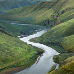
Sandstone pinnacle Larrabee State Park #47154r


Methow Valley Washington in winter

Methow Valley Winter

Methow Valley Winter

Methow Valley Washington in winterClearing fog near Mazama, Washington #56617  Purchase

Last month I made a quick trip to the Methow Valley in north-central Washington for some much-needed fresh air exercise and photos. The weather in western Washington had been fairly warm and rainy. So I headed to the east side of the North Cascades for a quick fix of winter conditions.

The Methow Valley is renowned for its extensive network of perfectly groomed cross-country ski trails and dependable snow cover. The area is also very popular with snowmobilers and backcountry skiers. They access the high country via the closed North Cascades Highway. On this trip, I stayed in the upper part of the valley near the Mazama area where I knew of several good spots for photographing if the light was right. Here are a few of the highlights from this trip.

Methow Valley barn, WashingtonBarn near Mazama, Washington #56601  Purchase

North Cascades Highway winter road closure near Mazama, WashingtonNorth Cascades Highway winter closure, near Mazama, Washington #56605  Purchase

Cross country skiing Methow Valley North CascadesCross-country skier on Methow Valley trails #56646  Purchase

Also, check out Methow Valley Fall Foliage to see another season in the Methow!

Leave No Trace

Please follow the guidelines of Leave No Trace (LNT). The Methow Valley and all other natural areas throughout the world are under incredible pressure from growing amounts of visitors. Please do your part to help preserve these precious areas for future generations!

To learn more about the principles and practicing LNT please take a few minutes to visit the Leave No Trace Center for Outdoor Ethics. Your children and grandchildren will thank you!

Seven Leave No Trace Principles

  • Plan ahead and prepare.                                       
  • Travel and camp on durable surfaces.                 
  • Dispose of waste properly.                                                                         
  • Leave what you find.                                            
  • Minimize campfire impacts (be careful with fire).
  • Respect wildlife.  
  • Be considerate of other visitors.

*Also, be respectful of private property. Many of the locations in this post are adjacent to private property. The Methow Valley Trail system often crosses private property boundaries and exists due to the blessing of local property owners. 

Photos appearing in Methow Valley Fall Foliage are available for Commercial Licensing and Fine Art Prints. Click on any image to purchase, or contact me for more info!

Table Mountain North Cascades Washington

Winter Heather Meadows Recreation Area

Winter Heather Meadows Recreation Area

Table Mountain North Cascades WashingtonTable Mountain Heather Meadows Recreation Area 56528  Purchase

Every winter for nearly twenty years I’ve made at least one visit to Heather Meadows Recreation Area. I come here for a variety of reasons, such as being close to home and one of the few places in the North Cascades with relatively easy access to subalpine and alpine terrain. Also because the scenery is some of the best in the state and the ever changing patterns of snow and light make for unique winter photography opportunities.

On this first trip of the 2015-2016 winter season I came mainly to begin getting in shape and acclimated for upcoming ski-photo tours. Last year was a near bust as far as snowpack is concerned, but so far this year winter storms have pounded the mountains resulting in a pretty impressive base. As of this writing the Mount Baker Ski Area reports 146″ in the upper runs, with more storms lined up waiting to dump more snow. The first break in the weather I’ll head back up for a few days of winter camping and photography.

Backcountry skiers North Cascades WashingtonBackcountry skiers heading up to Artist Point 56540  Purchase

Mount Baker in winter North CascadesMount Baker from Artists Point 56535  Purchase

Nooksack River North Cascades WashingtonNooksack River back down in the valley 56544  Purchase